
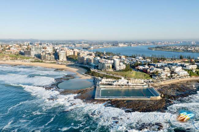
High resolution panoramic aerial photo of Newcastle East.
Photographer:
Mike Swaine, Above Photography
(Hire this photographer)
2.13 Km to Stockton in New South Wales Australia, Australia, New South Wales, Stockton, geo:lat=-32.923910, geo:lon=151.804430, geotagged. An incredible panoramic aerial photo of Newcastle East New South Wales 2300, this snapshot skillfully photographed in the Newcastle region is an up to date example of AeroStock's work all over the country.
| Photo ID | 31318 -25 |
| Licence type | Royalty-free |
| Location | 96 Nobbys Rd, Newcastle East NSW 2300, Australia |
| Taken | 2010:06:11 10:22:45 |
| Camera | Canon EOS-1Ds Mark III |
| Shutter speed | 1/1250 |
| Aperture | f/14 |
| Focal length | 90mm |
| ISO | 800 |
| Altitude | 100000 |
| Sequence | NC 00123028 |
Color palette
#303d48 #9e9794 #8a959d #726a66 #717e8f #546875Locations near Newcastle East
- Stockton
- Newcastle
- The Hill
- Cooks Hill
- Newcastle West
- Carrington
- Bar Beach
- Wickham
- The Junction
- Hamilton East
- Maryville
- Tighes Hill
- Merewether
- Hamilton
- Islington
- Hamilton South
Similar photos
NC 00123029

NC 00123026

NC 0123025

NC 00123025

140318 114110 Camera2 06772

140318 114111 Camera3 06774

140318 114110 Camera1 06771

140318 114106 Camera4 06768

140318 114121 Camera4 06775

NC 00123023

NC 0123023

NC 00123021

NC 0123021

NC 00123022

Newcastle 2300

NC 00123030

NC 0123030

NC 00123031

NC 0123032

NC 00123032

NC 00123033

140318 114126 Camera1 06778

140318 114127 Camera2 06780

140318 114055 Camera3 06766

140318 114127 Camera3 06781

140318 114055 Camera2 06765

140318 114055 Camera1 06764

NC 00123019

NC 0123020

NC 00123020

Newcastle 2300

NC 0123036

NC 00123036

Newcastle 2300

Newcastle 2300

NC 00123037

Newcastle Ocean Baths
140318 114050 Camera8 06763

Newcastle 2300

Newcastle 2300
